Saturday, 2 October 2010

Aus Day 13 - Head for the 'Centre of the Centre'

Saturday 2nd October Aus Day 13


I was woken at about 06.00 by the sound of a Myrna bird giving forth with a variety of different tunes. It was quite entertaining for the first 5 minutes but, then began to pale a little. However, he/she gave up after about 15 minutes and I drifted off to sleep again. I then didn’t waken until 08.00, my latest time yet but, I was not in a hurry so didn’t panic too much.

The usual shower and breakfast followed by a quick read of my emails to use up the last of my Internet time. Then, refuel and hit the road by 10.00. It is a bit cooler this morning with a stiff breeze blowing but, this eased as I drifted down the highway doing my impersonation of a Sunday afternoon driver. However, not far down the road I had to stop to take the following view of the George Gill Range where Kings Canyon is located.
George Gill Range from the Luritja Road
I called into the Kings Creek Road house with the main intention of getting a photo of Charlie, the cockatoo. Unfortunately, he was nowhere to be seen so, instead I managed to get the following snaps of a magpie and a piping shrike.
Magpie
Piping Shrike
Joined the Lasseter Highway at about 13.20 where, at the junction there is a “Red Centre Way” sign and curiously, a tree festooned with clothing. I have absolutely no idea why. Maybe someone can enlighten me.
The Red Centre Way Sign
Clothing Tree????
I also managed to get a couple of shots of this butterfly.
Butterfly
Same Butterfly
Setting off again I drifted slowly eastwards, making a brief stop at Mt Ebenezer Roadhouse and then pausing along the highway to photograph a few examples of the flora that I had been witnessing along the way, some of it in great profusion. I suspect that much of it will be burnt off and disappear again in the not too distant future.
Roadside Flora
Roadside Flora
Bush Just Coming Into Bloom
Arrived at Erldunda at 15.15. This is termed The Desert Oaks Resort and self styled “The Centre of the Centre.” I was soon booked in and found myself a very pleasant powered site shaded by trees and with a patch of grass on which I set up my table and chair and was soon enjoying a cooling beer.
Hard at Work - As Usual
Once again the site had no mobile phone network coverage, although it does have Cacti and a postage stamp size pool; but is covered by PieWiFi so was successful in connecting and holding a Skype session with the lovely Eileen. Soon after this I wandered over to the Tavern and treated myself to a beefburger and fries. However, this beefburger would have fed the 5,000, assuming they weren’t vegetarian. It even included bacon and egg. It was starting to get a little rowdy so retired to the van to complete this draft and upload Aus Day 12. With luck I may even get this one uploaded before Zebedee calls.
Cactus by the Erldunda Pool
The NOT Olympic Size Pool
The Erldunda Tavern
Well folks, that's it with posting this, I am fully up to speed and I have finally beaten Zebedee, so I will go to bed when I feel like. So There!!!

Aus Day 12 - Walk the Walk

Friday 1st October Aus Day 12


Up at 06.45 this morning, definitely getting better. Showered and breakfast then wrapped van up to be on my way by 08.00. I did the short drive to the Kings Canyon car park and was setting off on the Kings Canyon Rim Walk by 08.35

Since I have spent all of today in the Kings Canyon Area there won’t be a great deal of commentary. Who shouted Hurrah??? Instead I will just let the pictures and captions do the talking. However, since I ended up with about 70 pictures I have selected just a dozen to keep you going and they will be presented in Chronological order.

Start the Walk From the Car Park

What! - Up There???
The walk from the car park is very misleading as you are very quickly faced with a very stiff climb indeed. It is not long after commencing this climb that you realise why they advise that only reasonably fit and healthy people should attempt the Rim Walk but, I decided to go anyway. (Alright – who laughed?) Once at the top, the view is breathtaking. (no pun intended)
First view from the Rim overlooking the plain
However, not quite as breathtaking as when you are sat on the edge.
I was just sitting here, minding my own business
Jack Cotterill pioneered tourism at Kings Canyon and built a bridge across a chasm which gave views from the North wall. However, that bridge collapsed in 1991 and has since been replaced by a modern wooden structure. Once across the bridge (don’t look down) it gave access to views like these.
View from Cotterill's Lookout
View to the South Wall From Cotterill's Lookout
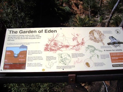
About halfway around the rim a wooden staircase led down into something of an oasis where trapped water gave rise to lush vegetation. The following pictures show the staircases in and out of “The Garden of Eden” and give some idea of the growth there.
Stairway into "The Garden of Eden"
Garden of Eden Information Board
Bridge Across "The Garden of Eden"
Stairway on the opposite side
Once around the other side of the rim this shot shows other people just accessing Cotterill’s lookout, having crossed the wooden bridge.

People Accessing Cotterill's Lookout Seen from the South Side
Not too long after this, the following sign came as something of a welcome relief as the temperature was now approaching 34 degrees and there wasn’t much shade to be had.
Nearly there!!!
This still left a kilometre to travel but it was now all downhill and relatively easy underfoot. Although I hadn’t been rushing and in fact had diverted from time to time to take photographs, I completed the walk in 2 hours and 35 minutes while the advertising brochure estimates 3 to 4 hours for the walk. My right ankle was feeling a little stressed but, nowhere near what I had expected. It is a walk I would recommend to anyone, assuming they are fit enough to do the initial climb, and some of the views are absolutely beautiful. Photographs don’t do it justice, particularly these which have been compressed for web usage.

Having completed the walk, I returned to the resort, gave the van a quick check over, oil, water etc and then spent the afternoon chilling out by drafting the Blog update. I think this is taking over my life. Mind you I did chance to get my legs out again; I even got some freckles emerging on my feet.
Well! That's the Van Sorted. What's Next?
Finished the day off by visiting the Dingo Bar for a beer and a meal of Barramundi and chips. All in all a good day was had by all until of course Zebedee said “and so to bed.”
The Dingo Bar - Not Bad For The Odd Beer or Two

Friday, 1 October 2010

Aus Day 11 - Kings Creek or Kings Canyon? Choices, Choices

Thursday 30th September Aus Day 11


Up in better time this morning (07.00) after being woken from 04.00 onwards by various groups setting off to do the Sunrise viewing of Uluru which, I decided to skip. It was much cosier in my bed.

Following the usual shower and breakfast, I drafted the Blog entry for Day 10 and was ready to depart by 09.30. However, I decided to take just a couple more shots of Uluru plus some of the Resort entrance and by the time I had fuelled up for the day I didn’t hit the road until 10.10, still I wasn’t in a tearing hurry.
Uluru in the Morning
Entrance Sign to Ayers Rock Resort
I suspected that, today there would not be much to stop for; particularly in the way of interesting photographs therefore I started to take a snap of the road head at each 10 to 20 kms just to try and demonstrate the changing terrain and vegetation. Consequently I ended up with some 20 views of the Road Ahead. However, don’t panic I have just picked a couple to show you.
Flat countryside with relatively sparse vegetation near Uluru
Undulating Terrain with Good Vegetation Cover on Luritja Road
The first stop I made was to get another shot of Mt Connor from the Lookout at about 11.30 then about 30 minutes later I arrived at the Kings Canyon turn off and turned North onto the Luritja Road. At a small rest area at 12.40 had a wander, to stretch my legs, and spotted a couple of pigeons snuggled together on the branch of a tree.
Aaaahhhhh - The Branch is Actually Horizontal
Another 80 kms saw me pulling into the Kings Creek Roadhouse which I had had recommended to me for a night stop. However, after a look around at some of the “attractions”, including Helicopter Rides, Camel Rides, Quad Biking and a very noisy cockatoo called Charlie, I spotted that their Internet was “temporarily unavailable” and decided that maybe the Kings Canyon Resort would be a better option so, saddled up and mossied on out of there.
Kings Creek Roadhouse
Camels, Ready to go - Kings Creek Roadhouse
I arrived at the Resort by 14.45 and booked in for two nights. The camp site was well laid out and even had areas of grass. Chose a powered site, near to the facilities, with some tree shade. Got the laundry underway for starters then settled down with a beer in the sunshine outside the van. I think this is the first time on this trip that I have had my legs out. Lovely aren’t they. However, one can’t seem to do much to beat the fly hazard although I have been trying some Tropical Strength insect repellent. Still haven’t decided if there is any improvement yet.
JB at Kings Canyon Resort Camp Site - Lovely Legs
The wind has now dropped to a gentle breeze and today’s max temperature is 29 while the forecast for tomorrow is 33 degrees. That’ll do for me Tommy!!! Indications are that Internet access is better here than at Ayers Rock Resort so fingers crossed. However, I do not have any mobile phone network cover. Still, I suppose one can’t have everything.

Hurrah, successful Skype session with Eileen and even a quick up-date with sister Valerie, then it was just time to beetle off up to the Sunset Viewing platform where I stood around with a small gaggle of others and managed to bang off some 43 photos and a couple of videos. Damn glad I’m not using roll film! Still here are just a couple for you to see.
Approaching Sunset at Kings Canyon Resort
Almost Sunset at Kings Canyon Resort
Following this I called into the Dingo Bar for a beer, with the laptop, to update the Blog. However, this proved to be too distracting so returned to the van to complete Wednesday’s update. Then of course, Zebedee arrived with his “and so to bed.”

Thursday, 30 September 2010

Aus Day 10 - Rock? - What Rock?

Wednesday 29th September Aus Day 10


Up late AGAIN this morning, this has got to stop. It was 07.40 this morning, the day is half gone. However, soon caught up and was on the road heading North by 09.15 and within 45 minutes reached the turn off for Uluru at Erldunda more commonly known as the Lesseter Highway or the “Red Centre Way”. I think it is known as this because more often than not, there is nothing to see but stunted vegetation and the red clay surface. However, just at the moment, there is hardly any red to be seen as everywhere is bursting with new growth, thanks to the unusual rainfall they have been having.

Now progressing in a westerly direction, I have my right arm liberally plastered with sun screen since without putting a long sleeve sweater on, I have no way of screening it from the intense rays of the sun. (sounds terrible doesn’t it). However, got to the Mt Ebenezer Roadhouse at 10.50 and had a quick wander about. Apparently the area got its name after a chap called Ebenezer Flint who helped pioneer the telegraph in the 19th century.
Entrance to Mt Ebenezer Roadhouse
At the turn off for Kings Canyon I stopped for a quick photo opportunity and obliged a family travelling with 3 children, by taking a photo of them all together with their camera. We naturally got talking and it turned out that she was brought up at Aldinga which is on the Fleurieu Peninsula, not far from Willunga where my sister Valerie lives. It’s a small world ain’t it?
Uluru Is Thataway ---->
Another 15 minutes or so to the West and I caught the first glimpse of what (apparently) many travellers think is Uluru. However, this is actually Mt Connor and apart from its different shape is a whole 4 metres smaller than Uluru. Whilst here, I also took a couple of snaps of some strange vegetation. Maybe someone can enlighten me as to what they are.
Mt Connor
Anybody Know What This Is?
Or These?
The next stop on the road was Curtin Springs Roadhouse which was very pleasantly set up and the bar had a myriad jokes adorning the walls. Outside there was an aviary with a selection of the local bird life but most impressive was the patch of grass and real trees.
Curtin Springs Roadhouse
Grass and Proper Trees at Curtin Springs
The Ayers Rock Resort is obviously a multi-million dollar enterprise which caters for millions of tourists each year. It is an enormous complex with 4 hotels, a shopping centre and an extensive camping ground with 176 sites. Having booked in, along with lots of others I located my site and then set off to visit “The Rock”. This involved purchasing a permit to the “Uluru-Kata Tjuta National Park” for £25.00 it is however, valid for 3 days. (Not that I will be needing it that long) Took the obligatory photographs although in many areas you are not allowed to stop and in some areas photography is also discouraged. It is certainly an impressive rock but, it is a long way to travel just to see it. In any case the climb was closed due to high winds at the summit.
No Prizes for Guessing What This Is
JB at Uluru
The Climb Point - Unfortunately Closed Today
Having circumnavigated the rock and briefly visited the cultural centre, I beetled back to the Resort to try and establish Internet access for a Skype session. Unfortunately, I couldn’t originally establish access at all and so had to resort to text messages. After having a spot of tea, I tried again and was able to establish slow access which enabled me to update the Blog for Aus Day 8, but not to establish any meaningful Skype contact. By the time it got to 10.30, I was feeling extremely frustrated and quite ready for Zebedee’s call of “and so to bed”.”

Aus Day 9 - Keep Going North Young Man

Tuesday 28th September Aus Day 9


Up late this morning, 07.30. The weather has turned cold and windy with a cloudy sky. Drafted an email after shower and breakfast and toddled off to the Internet access point to get it sent. Success. Got sorted and left the site at 09.30 but called into town(Coober Pedy) for a bit of shopping and fuel, then hit the road by 09.50 hoping to make Kulgera some 410 Kms North.

The CP Opal fields extend to about 40 Kms north of the town and then the terrain settles into the usual variation of shrub and brush as far as the eye can see. Stopped at the Pootnoura rest area at 10.35 having covered 75 kms from CP: If you read the sign below you will find that I am now in desert country with the Great Victorian Desert on one side with the Simpson Desert on the other.
Desert Country
The road continued like an unbroken ribbon into the distance and about an hour later I arrived at Cadney Park having now covered some 150 Kms. Parked up was one of the notorious Road Trains so, couldn’t let the photo opportunity go begging. When these things pass you at 100 kms per hour, you need to be careful you don’t get blown off the road.
Cadney Park Roadhouse
Road Train Parked up at Cadney Park Roadhouse
12.35 saw me at Marla (237 Kms) and another 11 kms up the road I couldn’t resist taking this photo of the Ghan railway line which runs from Adelaide to Darwin and follows the Stuart Highway for much of the time.
What - No Trains?
The next stop along the way which should have revealed more about the Explorers, was the Marryat Rest Area but, unfortunately, Australia suffers from vandals as well, an all the information boards were missing. However, I was now some 358 Kms from CP.

Finally, at 14.45, I reached the South Australia/Northern Territory State Border as the following pictures prove.
Northern Territory State Border
JB About to Enter The Northern Territory
Over the Wall and Looking Back
It was interesting to note the subtle difference in road management having crossed the border, a sign proclaimed “The speed limit in the Northern Territory is 110 KPH unless signed otherwise” about 100 metres beyond this was a 130KPH speed limit sign. Mind you I didn’t really want to see if my little old camper van could actually achieve such a speed without falling apart so stayed at a more modest 100 KPH.

I reached my intended destination at the Kulgera Roadhouse by 15.30 and within 15 minutes had discovered that Internet access was available, but my mobile was a dead as a dodo. However, soon set up with camp chair and table outside the van in shorts and tee-shirt enjoying a beer.

It has been a good drive up, although not much variation in the landscape I had emerged into sunshine at about 11.15 and although starting to cloud over again it is still warm. Managed to sort myself out a bit of tea later although I have just found out that I haven’t been supplied with a can opener. How is a single guy supposed to manage without a can opener???

There is a wind getting up so retired to the roadhouse bar with the laptop in order to draft yesterday’s Blog although I have not been able to post it yet. The text isn’t too much of a problem but posting the pictures takes a considerable time and I may have to consider limiting them in the future. Anyway, completed the draft and was then ejected from the roadhouse at 9.30 pm because they were closing. So, back to the van and a game or three of Majong then once again, “and so to bed,” said Zebedee