Friday, 8 October 2010

Aus Days 17 & 18 - Its Raining & A Change of Destination

Wednesday 6th October Aus Day 17


Woke up this morning to the sound of rain so decided to spend some time drafting the Blog, which I was too shattered to do last night, and carrying out some much needed computer housekeeping, file tidying, virus software updating, etc. I doing this, by the wonders of modern technology, I retrieved (from my computer back in the UK) a copy of a picture I had taken at the Alice Springs Water Hole in 2000 and, as I had mentioned, a quick glance will verify that there was more water at that time.
Alice Springs Water Hole Taken in February 2000
I did manage to get into town for about an hour or so this afternoon, and picked up a CD of "The Best of Cream", a band from the 60s, to add to my collection. This was a band comprising Ginger Baker, Eric Clapton and Jack Bruce, that played between July 1966 and November 1968. This CD features 2 of my favourites, “Sunshine of your love” and “White room” so, of course, I just had to have it.

The rain renewed its vigour so I retreated to the camp site and busied myself trying to sort out my back-up HDD which is currently giving me a hard time.

Then of course nothing else much happened until Zebedee came aknocking and crying “and so to bed.”
________________________________________________________________________________

Thursday 7th October Aus Day 18

Well, the rain was still at it this morning having continued through most of the night and the temperature has dropped considerably. However, I have to depart today so, showered, breakfast and then made preparations to depart, not forgetting to use up my remaining Internet time with a couple of quick emails. Off site by 09.45, not forgetting to collect my $10 key deposit on the way out, down the road to refuel and then hit the Stuart Highway once again heading for Barrow Creek. (More of that later). As I was leaving, the rain was still falling and the temperature was 16 degrees. Ridiculous!
Leaving Alice Springs - Cold, Wet and Windy
Approximately 17 miles north of Alice Springs one crosses the Tropic of Capricorn so naturally one has to stop for a photo call:
JB at the Tropic Of Capricorn - Camera in van out of the Rain
I was already beginning to notice a number of differences since I had travel this way in Feb 2000 and this area was one such change. Although the landmark itself hasn’t changed it is now secluded from the highway in a rest area behind a hedge. In 2000 it was directly accessible from the road. I also later became convinced that the entire highway has been upgraded and widened.

Almost 2 hours after leaving Alice I had covered the 135 kms to the Aileron Roadhouse where these enormous aboriginal figures can be seen.
Giant Anmatjere Man at the Aileron Roadhouse
Giant Anmatjere Woman and Child
An hour after this I had a quick rest stop at the Ti Tree Roadhouse which sports a very interesting bar which, naturally was vacant at this time of day.
Flo's Bar at the Ti Tree Roadhouse
Just a little further up the highway I came to another historical information area, dedicated to John MacDouall Stuart and William Kekwick who, on 23rd April 1860 ascended and named Mt Sturt, in the local vicinity, but this was later renamed Central Mt Stuart. John MacDouall Stuart had calculated with a sextant that Central Mt Stuart is the geographical centre of Australia. (Not quite right but, close.)
The Stuart Memorial at the Central Mt Stuart Rest Area
I was now approaching my proposed destination of Barrows Creek and the time was 13.55. However, when I clapped eyes on the place the first thing that came to mind was my sister Valerie exclaiming in a shocked voice “you’re not going to stop there, are you?” Well, take a look at the photo below and make up your own mind but I decided to press on.
Barrow Creek Roadhouse - There is nothing else there!
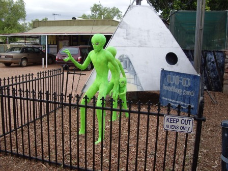
Unfortunately, time was now getting on and I had to cover another 225 kms to get to Tennant Creek which was the next decent town of any sort. So, the Sunday Driver attitude had to go and I found that the little old camper van could quite happily accelerate to 130kph. However, the gusty crosswinds made the direction of travel a little uncertain at times. Still, an hour later I made it to Wycliffe Well, where I refuelled and then beat a hasty retreat from the alien landing force:
Alien Invasion at Wycliffe Well?
More Aliens - UFO Capital of Australia?
Could the Aliens be as a result of the selection of beers in the bar?
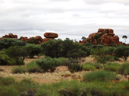
Having escaped the aliens I was next confronted by the “Devil’s Marbles”, a series of giant granite rocks seemingly perched haphazardly atop one another. Actual a process of erosion over millions of years. This was another area that I had visited previously and I am convinced that the road that runs directly past the rocks, in a sort of extended lay-by, was the original route of the highway. I must try and dig out the photograph I took at the time.
Devil's Marbles
A Series of  Weathered Granite Rocks
Eroded over Millions of Years - They Were Certainly There in the Year 2000
Leaving the Marbles behind I continued my dash for Tennant Creek and arrived there at about 16.30. Found a convenient Caravan Park, (maybe not the best) and then had to decamp about 100metres up the road to the BP filling station in order to establish Internet access. However, this successfully achieved I was back to the camp site, made tea and spent the evening drafting this Blog update which, of course, I will have to try and post tomorrow. In any case it’s nearly time for Zebedee.

Wednesday, 6 October 2010

Aus Day 16 - Preservation and Water Holes

Tuesday 5th October Aus Day 16


Well! It managed to rain pretty much all night and it was still at it when I managed to get myself out of bed at 07.30 this morning. Still, it is a little cooler so that’s not bad. The usual shower and breakfast and cleared the caravan by 09.50. I will be moving to a different site this afternoon as this one is rather expensive for my budget which is taking a bit of a hammering at the moment. Still within overall budget but, Mr Micawber would not be happy with the trend.

First stop today is at the Old Ghan Railway Museum which is about 8 kms south of the town centre and features mementoes of the original narrow gauge Ghan Railway which ran from Port Augusta to Alice Springs, via Oodnadatta and strange as it might seem, suffered from significant flood problems. The South Australian Government authorised construction of the line in 1876 and by 1891 had reached Oodnadatta. However, it wasn’t until 1925 that the decision was made to extend the line to Alice Springs and it didn’t reach there until 1929. At that time the town of Alice Springs was known as Stuart and was not renamed as Alice Springs until 1933.

The Ghan Preservation Society has a wealth of information in their little museum and I photographed much of it. Unfortunately, it doesn’t translate to Blog format and so I have just the following few photos of the train which the Society still operates once a week. Unfortunately for me, on a Sunday.
Preserved Commonwealth Railways Locomotive & Train No 58
1st Class Saloon Bar
JB In the Saloon Bar - Damn it's closed!
1st Class Dining Car
Not Indicated but Assume 3rd Class Dining Car
Galley
Naturally, passengers would need somewhere to relieve themselves from time to time to toilets were available but, then as now, not to be used when the train is in the station.
Toilet and Fold Up Wash Basin
On the weekly Preservation Society trips, apparently there is a more modern type of carriage to cater for the photographic ambitions of the tourists. Shown below!!!
Modern Tourist Class??
Finally, tucked away at the back of the yard the Society has an older steam engine (3’ 6” Gauge, 4-8-2) preserved, sadly, not in working order although an entry on the Internet seem to think otherwise.
Narrow Gauge Steam Locomotive "Lou Marks"
JB With Lou Marks
I extracted myself from the museum at about 11.20 and headed to the opposite side of town to the Alice Springs Telegraph Station.

In 1871, William Whitfield Mills, a surveyor for the Overland Telegraph, discovered and named the ‘Alice Springs’ waterhole after Alice Todd, the wife of Charles Todd, the Superintendent of Telegraphs. It isn’t actually a spring at all; it’s a depression in the riverbed where water gets trapped on top of some granite.

I was here in February 2000 and it was pretty much as I remembered it other than, I remember there being more water at that time. However, the photographs from 2000 are resident on my computer back in the UK and not readily available for comparison. On this visit, I took a hike up to the top of Trig Hill which was established as part of the map making process. The following photo was taken at the top and I think you can tell that it was quite windy.
On Top of Trig Hill at the Alice Springs Telegraph Station
The following shots show me ‘posing’ in front of the waterhole where, in the 1920s, men were pictured diving into the water; and then with a view of the river course behind me.
JB at the Water Hole - People used to dive from the rock into the water
JB and The Continuing River Course
Having had a good wander about, including having a quick play with this operational water pump, I decided to call it a day and head for the new caravan site. However, just to complete the story the original Telegraph Station buildings have been preserved on the site and are accessible to tourists for a modest entry fee. I didn’t bother this time as Christine and I had done the complete tour in 2000.

JB Operating the Water Pump - Still from a Video
I called into the town centre to do a bit of shopping and generally have a browse around, taking the following couple of shots of Todd Mall. However, my overall impression is that the area has developed a slight air of seediness and is looking a bit tired. It certainly doesn’t look, to me, as fresh as it did in 2000. However, others will have to make up their own minds.
Todd Mall Sign
Centre of Todd Mall
Having done my shopping in the famous ‘Coles’ supermarket I found my way to the Stuart Caravan and Cabin Park, where I booked in by 15.30 and shortly after was enjoying a refreshing dip in the pool which, I followed with a shower and then got set up for my really welcome Skype session with the very lovely Eileen.

Tea of spaghetti bolognese and then an evening sorting out and labelling the 70 odd photographs and videos I had taken during the day. After which, I felt too tired to daft the Blog {Zebedee sneaked up on me and sent me to bed at about 10.30} which is why I am doing this on Wednesday morning. Well it is raining again and I am not in a hurry to go anywhere.

Monday, 4 October 2010

Aus Day 15 - Gorges and Chasms

Monday 4th October Aus Day 15


Up at 07.30 after a good night’s sleep, despite the warmth and humidity. I have also got the Mossie zapper out and working so that sorted the little blighters. Shower, breakfast, emails and travel accounts all sorted before 08.00 so once I got the van packed away and went to get fuel I was on the road to Ormiston Gorge some 127 kms west of Alice along Namatjira Drive and into the West MacDonnell National Park. I wanted to get there in reasonable time so abandoned my Sunday Driving habits and arrived at the Gorge by 10.15. This is another place that I have visited before in February 2000 and It was pretty much as I remembered it apart from there being more water. The Gorge has a near permanent water hole which is reportedly 14 metres deep
Ormiston Gorge Waterhole
Ormiston Gorge - 130 Kms West of Alice Springs
After wandering around for about an hour and attempting some video photography of a small dragonfly (with limited success) I moved on about 12 kms further along Namatjira Drive and paid a quick visit to Glen Helen Gorge which has its own attributes but, is not as spectacular as Ormiston.
Glen Helen Gorge
It was now approaching 12.00 and I decided to start on the return journey, at a slower pace and at 12.25 stopped off at the Ochre Pits. The colourful ochre bearing cliffs at this site represent some 700 million years of geological history and they have played an important role in the culture of the local aboriginal people.
Ochre Cliffs
Ochre Cliffs Approx 120 Kms west of Alice Springs
A little further back towards Standley Chasm, I stopped at the Neil Hargrave Lookout and took this shot of the West MacDonnell Range.
West MacDonnell Range from Namatjira Drive
I thought that you might want some evidence of the water that has been falling in the area of late so took the following pictures of one of the road floodways actually doing its job. Alright, it isn’t much but last time I was here this whole region was absolutely bone dry and burnt to a crisp.
Floodway for the Hugh River
Hugh River Floodway over Namatjira Drive
And so to Standley Chasm. This is about 10 kms off the Larapinta Drive and is privately owned and operated. Consequently there is a small fee to pay. However, imagine my dismay when I was offered a concessionary fee without even asking. Cheek! The actual Chasm is about a 20 minute scramble up the river bed and is actually a narrow cleft in the rock face. Again, I have visited the Chasm before and have a very similar picture of myself, as the third of these, from that time.
Pathway getting up to the Chasm
Standley Chasm
JB in Standley Chasm - Again!
After negotiating my way back to the car park it was nearly 3.00 pm and I still had to get into Alice to do some shopping before my scheduled Skype call at 5.00 pm but, I managed this shot of the MacDonnell Range along the Larapinta Drive just outside Alice.
MacDonnell Range looking east on Larapinta Drive
Needless to say, I made it back in time but by the time I had parked the van up for the night it was beginning to look as though the forecast for rain was going to come true before the night was out.
Will it? or Won't it?
I think it just might!
As I sit here drafting this update, the forecast has come true and we have rain falling and we have also had thunder and lightning. Magic! Still it should cool things down a little. However, the forecast for the rest of the week is getting cooler with Thursday being forecast for a max temperature of 20 degrees. Where’s my sweater!!! I’ll bet that Zebedee has got it to go to bed in!

Sunday, 3 October 2010

Aus Day 14 - Into "The Alice"

Sunday 3rd October Aus Day 14


Up at 07.00 and followed the usual routine of shower, and breakfast. This was followed by a quick update of my travel accounts (Yes, I know, boooorrrrring) and transmission of emails. I noticed while doing this that Ed Milliband has beaten his brother David for leadership of the Labour Party. David, not being a sore looser, immediately resigned from front line politics. Ahh, shame!!! Still, at least Ed Balls didn’t win.

Anyway, photographed the van on the site at Erldunda along with a cat which seemed to have befriended me, before I hit the road at about 09.30 after refuelling, with only the short hop of 200 kms to do to Alice Springs. Consequently, being Sunday, I was soon crawling along at a good 40 kph BELOW the speed limit. I was so excited when I got to the first rest area at 10.00 that I spent some time there videoing ants. Yes, that’s right, ants.
Van very pleasantly situated at Erldunda

Not MY Cat
Moving on from there I decided to excite you with a view of the terrain along the Stuart Highway:
Look to the future my son.
And then got so overwhelmed at seeing a rocky outcrop I had to stop and record it for posterity:
Rocky outcrop 58 kms north of Erldunda
Then at 10.50 I came across a real part of ancient history as I crossed the Finke River. Parts of this river bed date back some 350 million years and while it is often totally dry, at other times it becomes a raging torrent. However, today it just has a gentle stream running along the centre of the river bed:
Finke River where it is crossed by the Stuart Highway
Finke River - 350 Million years old?
About half an hour after moving on and just south of Stuart’s Well, I was attracted by a monument to a number of people who were killed on 24th May 1994 during the inaugural Northern Territory Cannonball Run. I feel sure that someone out there will know all about this event.
Cannonball Memorial
Just a little further was the Stuart’s Well Roadhouse which was founded by Jim Cotterill, the son of Jack Cotterill who had opened up tourism in the Kings Canyon. Parked out front is what remains of the Dodge Truck, Jack had used in his exploits in the 1960s. Oh! I also saw my first emu.
Dodge Truck Circa 1950s
Emu at Stuart's Well Roadhouse
Despite applying my very best Sunday driving techniques I was unable to prevent myself getting to Alice Springs by shortly after 13.00 so, I decided to do a bit of shopping before finding the Tourist Information Office and identifying the location of the most likely Caravan Parks. I eventually decide to go upmarket and went for the ‘Macdonnell Range Holiday Park.’ Having established location, I felt I still had plenty of time to do my first touristy bit and headed for Anzac Hill. I had been here before in February 2000 with my late wife Christine and I was keen to see if it still looked the same. Well the views over the town and surrounding hills were very familiar but unfortunately the Memorial itself was fenced off, presumably for restoration work.
View from Anzac Hill looking down Bath Street
JB on Anzac Hill
Anzac Hill looking towards Mt Gillern
Once I back at the Caravan Park which, not only had a very pleasant site for me but also a usable pool into which I felt obliged to plunge and I got some very obliging German chap to take the following photo as evidence. Following which I was compelled to relax with a beer while sunning myself outside the van.
Quick dip anyone?
How about a beer then?
Well that’s about all there is to report today apart from the usual Blog draft and the continuing infernal saga of the damned frustrating Internet, Skype connection. As you may be able to tell, it didn’t perform too well this evening. Still, I suppose one has to remember what the likes of Stuart and other pioneers had to contend with and take it all with a pinch of salt. Anyway, I am sure that I can hear that character Zebedee about to spring out with his usual cry of “and so to bed.”