Wednesday 6th October
Aus Day 17
Woke up this morning to the sound of rain so decided to spend some time drafting the Blog, which I was too shattered to do last night, and carrying out some much needed computer housekeeping, file tidying, virus software updating, etc. I doing this, by the wonders of modern technology, I retrieved (from my computer back in the UK) a copy of a picture I had taken at the Alice Springs Water Hole in 2000 and, as I had mentioned, a quick glance will verify that there was more water at that time.
 |
| Alice Springs Water Hole Taken in February 2000 |
I did manage to get into town for about an hour or so this afternoon, and picked up a CD of "The Best of Cream", a band from the 60s, to add to my collection. This was a band comprising Ginger Baker, Eric Clapton and Jack Bruce, that played between July 1966 and November 1968. This CD features 2 of my favourites, “Sunshine of your love” and “White room” so, of course, I just had to have it.
The rain renewed its vigour so I retreated to the camp site and busied myself trying to sort out my back-up HDD which is currently giving me a hard time.
Then of course nothing else much happened until Zebedee came aknocking and crying “and so to bed.”
________________________________________________________________________________
Thursday 7th October
Aus Day 18
Well, the rain was still at it this morning having continued through most of the night and the temperature has dropped considerably. However, I have to depart today so, showered, breakfast and then made preparations to depart, not forgetting to use up my remaining Internet time with a couple of quick emails. Off site by 09.45, not forgetting to collect my $10 key deposit on the way out, down the road to refuel and then hit the Stuart Highway once again heading for Barrow Creek. (More of that later). As I was leaving, the rain was still falling and the temperature was 16 degrees. Ridiculous!
 |
| Leaving Alice Springs - Cold, Wet and Windy |
Approximately 17 miles north of Alice Springs one crosses the Tropic of Capricorn so naturally one has to stop for a photo call:
 |
| JB at the Tropic Of Capricorn - Camera in van out of the Rain |
I was already beginning to notice a number of differences since I had travel this way in Feb 2000 and this area was one such change. Although the landmark itself hasn’t changed it is now secluded from the highway in a rest area behind a hedge. In 2000 it was directly accessible from the road. I also later became convinced that the entire highway has been upgraded and widened.
Almost 2 hours after leaving Alice I had covered the 135 kms to the Aileron Roadhouse where these enormous aboriginal figures can be seen.
 |
| Giant Anmatjere Man at the Aileron Roadhouse |
 |
| Giant Anmatjere Woman and Child |
An hour after this I had a quick rest stop at the Ti Tree Roadhouse which sports a very interesting bar which, naturally was vacant at this time of day.
 |
| Flo's Bar at the Ti Tree Roadhouse |
Just a little further up the highway I came to another historical information area, dedicated to John MacDouall Stuart and William Kekwick who, on 23rd April 1860 ascended and named Mt Sturt, in the local vicinity, but this was later renamed Central Mt Stuart. John MacDouall Stuart had calculated with a sextant that Central Mt Stuart is the geographical centre of Australia. (Not quite right but, close.)
 |
| The Stuart Memorial at the Central Mt Stuart Rest Area |
I was now approaching my proposed destination of Barrows Creek and the time was 13.55. However, when I clapped eyes on the place the first thing that came to mind was my sister Valerie exclaiming in a shocked voice “you’re not going to stop there, are you?” Well, take a look at the photo below and make up your own mind but I decided to press on.
 |
| Barrow Creek Roadhouse - There is nothing else there! |
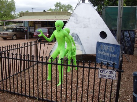
Unfortunately, time was now getting on and I had to cover another 225 kms to get to Tennant Creek which was the next decent town of any sort. So, the Sunday Driver attitude had to go and I found that the little old camper van could quite happily accelerate to 130kph. However, the gusty crosswinds made the direction of travel a little uncertain at times. Still, an hour later I made it to Wycliffe Well, where I refuelled and then beat a hasty retreat from the alien landing force:
 |
| Alien Invasion at Wycliffe Well? |
 |
| More Aliens - UFO Capital of Australia? |
 |
| Could the Aliens be as a result of the selection of beers in the bar? |
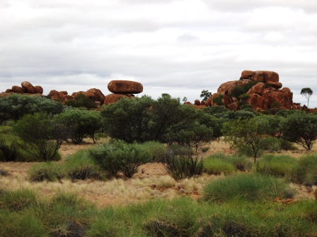
Having escaped the aliens I was next confronted by the “Devil’s Marbles”, a series of giant granite rocks seemingly perched haphazardly atop one another. Actual a process of erosion over millions of years. This was another area that I had visited previously and I am convinced that the road that runs directly past the rocks, in a sort of extended lay-by, was the original route of the highway. I must try and dig out the photograph I took at the time.
 |
| Devil's Marbles |
 |
| A Series of Weathered Granite Rocks |
 |
| Eroded over Millions of Years - They Were Certainly There in the Year 2000 |
Leaving the Marbles behind I continued my dash for Tennant Creek and arrived there at about 16.30. Found a convenient Caravan Park, (maybe not the best) and then had to decamp about 100metres up the road to the BP filling station in order to establish Internet access. However, this successfully achieved I was back to the camp site, made tea and spent the evening drafting this Blog update which, of course, I will have to try and post tomorrow. In any case it’s nearly time for Zebedee.


No comments:
Post a Comment
Leave your Comments/Thoughts/Suggestions here.