Monday 4th October
Aus Day 15
Up at 07.30 after a good night’s sleep, despite the warmth and humidity. I have also got the Mossie zapper out and working so that sorted the little blighters. Shower, breakfast, emails and travel accounts all sorted before 08.00 so once I got the van packed away and went to get fuel I was on the road to Ormiston Gorge some 127 kms west of Alice along Namatjira Drive and into the West MacDonnell National Park. I wanted to get there in reasonable time so abandoned my Sunday Driving habits and arrived at the Gorge by 10.15. This is another place that I have visited before in February 2000 and It was pretty much as I remembered it apart from there being more water. The Gorge has a near permanent water hole which is reportedly 14 metres deep
 |
| Ormiston Gorge Waterhole |
 |
| Ormiston Gorge - 130 Kms West of Alice Springs |
After wandering around for about an hour and attempting some video photography of a small dragonfly (with limited success) I moved on about 12 kms further along Namatjira Drive and paid a quick visit to Glen Helen Gorge which has its own attributes but, is not as spectacular as Ormiston.
 |
| Glen Helen Gorge |
It was now approaching 12.00 and I decided to start on the return journey, at a slower pace and at 12.25 stopped off at the Ochre Pits. The colourful ochre bearing cliffs at this site represent some 700 million years of geological history and they have played an important role in the culture of the local aboriginal people.
 |
| Ochre Cliffs |
 |
| Ochre Cliffs Approx 120 Kms west of Alice Springs |
A little further back towards Standley Chasm, I stopped at the Neil Hargrave Lookout and took this shot of the West MacDonnell Range.
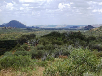 |
| West MacDonnell Range from Namatjira Drive |
I thought that you might want some evidence of the water that has been falling in the area of late so took the following pictures of one of the road floodways actually doing its job. Alright, it isn’t much but last time I was here this whole region was absolutely bone dry and burnt to a crisp.
 |
| Floodway for the Hugh River |
 |
| Hugh River Floodway over Namatjira Drive |
And so to Standley Chasm. This is about 10 kms off the Larapinta Drive and is privately owned and operated. Consequently there is a small fee to pay. However, imagine my dismay when I was offered a concessionary fee without even asking. Cheek! The actual Chasm is about a 20 minute scramble up the river bed and is actually a narrow cleft in the rock face. Again, I have visited the Chasm before and have a very similar picture of myself, as the third of these, from that time.
 |
| Pathway getting up to the Chasm |
 |
| Standley Chasm |
 |
| JB in Standley Chasm - Again! |
After negotiating my way back to the car park it was nearly 3.00 pm and I still had to get into Alice to do some shopping before my scheduled Skype call at 5.00 pm but, I managed this shot of the MacDonnell Range along the Larapinta Drive just outside Alice.
 |
| MacDonnell Range looking east on Larapinta Drive |
Needless to say, I made it back in time but by the time I had parked the van up for the night it was beginning to look as though the forecast for rain was going to come true before the night was out.
 |
| Will it? or Won't it? |
 |
| I think it just might! |
As I sit here drafting this update, the forecast has come true and we have rain falling and we have also had thunder and lightning. Magic! Still it should cool things down a little. However, the forecast for the rest of the week is getting cooler with Thursday being forecast for a max temperature of 20 degrees. Where’s my sweater!!! I’ll bet that Zebedee has got it to go to bed in!


No comments:
Post a Comment
Leave your Comments/Thoughts/Suggestions here.